The southeastern coast of the United States is currently facing a serious weather threat as a tropical-like front stalls over the region. This slow-moving weather system is bringing heavy rains and increasing the risk of sudden flash floods. Residents and travelers along the coastline between Charleston, South Carolina, and Savannah, Georgia, are advised to stay alert and prepared for rapid changes in weather conditions.
Flash floods are especially dangerous because they happen quickly, often with little warning. The stalled front means continuous rain, which can overwhelm local drainage systems and rivers. For those in the affected areas, understanding the risks and knowing what safety steps to take is crucial. This article will explain the situation clearly and provide useful tips on how to stay safe as flood risks rise.
What Is Causing the Tropical-Like Front to Stall?
A tropical-like front is a weather pattern that behaves similarly to a tropical storm but does not meet all the criteria to be classified as one. In this case, warm, moist air from the ocean meets cooler air over the land, creating a zone of heavy rain. Normally, these systems move quickly and change the weather in a short time.
However, when such a front stalls or stops moving, it means that the rain keeps falling over the same area. This is exactly what’s happening over the southeastern seaboard. Warm ocean winds and a weak pressure system are preventing the front from moving away, increasing the chance of flooding. The longer the rain stays, the more water collects on roads and low-lying areas.
Which Cities Are Most At Risk?
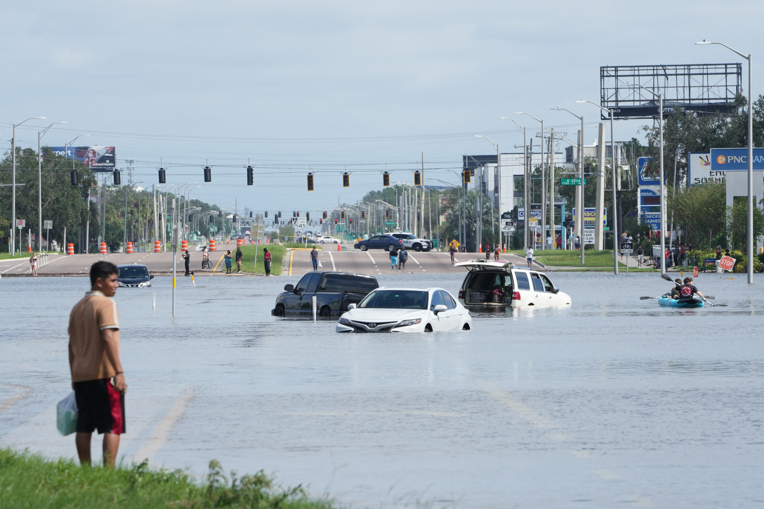
Authorities have identified cities along the coast from Charleston in South Carolina to Savannah in Georgia as most at risk. Both cities have low-lying areas that can flood quickly if heavy rains continue. These urban areas also have rivers and streams that can overflow during intense downpours.
Charleston has experienced flood issues in the past due to its coastal location and flat landscape. Savannah, known for its beautiful historic district, also faces flood risks from the nearby rivers and marshlands. Residents in these cities are strongly encouraged to keep an eye on weather updates and flood warnings from local authorities.
Why Flash Floods Are Dangerous
Flash floods happen rapidly, often within minutes or hours of heavy rainfall. They can sweep away cars, block roads, and damage homes without much warning. Many flash floods occur after intense storms dump large amounts of rain in a short time.
Because the tropical-like front is stalled, rainwater has little chance to flow away naturally. This can cause sudden floods even in areas where flooding is uncommon. It’s important to remember that flash floods are some of the most dangerous types of floods because they give little time to react.
How to Stay Safe During Flash Flood Threats
Safety should always be the first priority when flood alerts are issued. Here are some simple tips to help stay safe during this period of elevated risk:
Stay tuned to local news and weather reports for updates.
Avoid driving through flooded roads. Even shallow water can sweep vehicles away.
Keep emergency supplies ready, including drinking water, food, and first aid kits.
Move to higher ground if you are in a low-lying area prone to flooding.
Do not ignore flash flood warnings. Follow instructions given by local officials.
How This Weather Event Affects People Beyond the US Southeast
While this stalled tropical-like front is mainly affecting the Southeastern US, the news holds lessons for all regions, including India. With climate change, weather patterns worldwide are becoming more unpredictable. Sudden floods and intense rainstorms are more common now than before.
Indian cities like Mumbai, Chennai, and Kolkata often face similar flash flood threats during the monsoon. Young people should learn from events like this to better prepare for emergencies and support community safety. Awareness and quick action are key to reducing harm from flooding anywhere in the world.
The Role of Weather Technology and Forecasting
Modern weather forecasting tools have improved the ability to predict and track stalled fronts and heavy rain events. Satellite images, radar data, and computer models all help meteorologists warn the public before floods happen. This technology is vital for protecting lives and property.
However, technology alone is not enough. People need to respond to alerts seriously and plan ahead. Understanding weather risks and preparing for emergencies helps reduce damage and ensures quicker recovery after floods.
Conclusion: Stay Alert and Prepared
The current tropical-like front stalling over the southeastern US seaboard is a serious weather event causing flooding alerts to rise. Cities between Charleston and Savannah are most at risk for sudden flash flood events that can quickly become dangerous. Staying informed through trusted news sources and following safety advice can protect lives and property.
For young readers, this serves as an important reminder that weather can change fast and have serious impacts. By staying aware and prepared, we can better face challenges from floods and storms, no matter where we live. Always take flood warnings seriously and act quickly to stay safe.